Developed by CNES in cooperation with EUMETSAT, the IASI instrument (Infrared Atmospheric Sounding Interferometer) flies onboard the European meteorological satellites, Metop. Its strength: aside from measuring the temperature and humidity of the atmosphere, IASI also measures more than 33 atmospheric components with high precision, and is also used to monitor the climate.
The IASI remote sensing instrument was designed at the end of the 1980’s to fulfil the needs of 3 different communities:
- meteorologists asking for an “imager” instrument with a good spatial coverage, the capability to measure vertically-resolved water vapour and temperature, along with pixel small enough to have a better chance to avoid clouds,
- the atmospheric sounding community wanting a high spectral resolution and extended spectral range to favour the possibility to measure concentrations for a series of gases with vertically-resolved information,
- scientists from the climate community insisting on the high stability and optimized radiometric specifications to obtain accurate observations.
The first IASI instrument was launched onboard the Metop-A polar-orbiting satellite in 2006, followed by a second and third similar instruments on Metop-B and Metop-C at the end of 2012 and 2018, respectively.
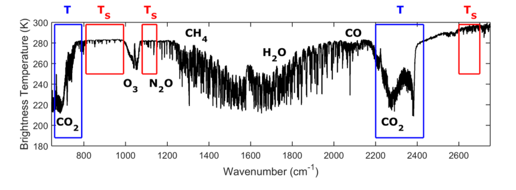
IASI consists of a Fourier transform spectrometer (FTS) associated with an imaging instrument. It is designed to measure the outgoing top-of-atmosphere radiation spectrum emitted by the Earth-atmosphere system in the thermal infrared spectral range, using nadir geometry. Measurements are performed from the Metop polar orbit, at an altitude of ~817 km. The satellite is sun-synchronous with a 98.7° inclination to the equator, and the satellite’s ground track is at about 09:30 local time in the morning (and 21:30 in the evening). The time to complete an orbit is about 101 minutes, which implies that Metop makes a little more than 14 orbits a day. To achieve global coverage, the IASI instrument observes the Earth up to an angle of 48.3° on both sides of the satellite track. This corresponds to 2 x 15 mirror positions and a swath of about 2 x 1100 km. Each instantaneous field-of-view (3.3° x 3.3° or 50 km x 50 km at nadir) is composed of 2 × 2 circular pixels, each corresponding to a 12 km diameter footprint on the ground at nadir. The instrument uses three detectors to fully cover the spectral range that extends from 645 to 2760 cm-1 (15.5 to 3.62 µm) with no gaps. The IASI Level1 processing generates calibrated and apodized atmospheric spectra (L1C) from raw interferograms. The raw on-fly spectra are of high radiometric quality, with a noise equivalent temperature difference well below 0.1 K between 1150 and 1500 cm-1, lower than 0.2 K between 1500 and 2200 cm-1, except for the narrow portion between 1800 and 2000 cm-1 where it reaches 0.3 K. It starts to increase above 2500 cm-1, where the thermal infrared emission drops.
The spectral resolution is driven by the FTS optical path difference, which is 2 cm. This leads to a spectral resolution (full width at half maximum) varying between 0.35 and 0.5 cm-1 depending on the wavelength. For convenience, the standard radiance (L1C) products are apodized by a Gaussian function of 0.5 cm-1 full width at half maximum, which can be considered as the apodized spectral resolution. Each spectrum is sampled every 0.25 cm-1, providing a total of 8461 radiance channels. The IASI mission delivers more than 1 200 000 observation spectra per day (15 GB). The acquisition of one complete across track scan of IASI, including onboard calibration, takes 8 seconds. This corresponds to 120 (30 x 4) interferograms. On-board processing reduces the data rate from 45 Megabits per second (interferograms) to 1.5 Megabits per second (spectra). These spectra are down-linked from the satellite to the ground in near real time (about 3 hours after acquisition). The IASI products are operationally distributed via Eumetsat’s Data Distribution System (EumetCast).